ATLANTIC AND PACIFIC NAMED STORMS
2011
Last Advisory for Each Storm
June 21, 31, July 21 July 31, Aug. 5, 20, 30, Sept. 4, 14, 29, Oct. 4, 14, 19, Nov. 13, (18, 20-23)
(This is still a work in progress
---
but put on hold for now because I must do other things for now.
However, all the links to when each storm expired can be found below to verify
that they terminated when predicted --
as well as four more not expressly foretold beforehand, but implied to occur as
can be seen in early documents.
(Example: See +3.5 years to TS
Olga on the regular Jewish calendar from the same Bible-Code
Pictogram,
thereby implying another 3.5 years on the regular Jewish calendar,
just as the rest of the storms were predicted, except using the usual 360
calendar.
These four extra storms occurred on the regular
Jewish calendar.)
All information below is in rough and incomplete. Please keep that in mind! But links are accurate.
For the actual
predictions made for each storm,
and what each one meant at the time,
please click here!
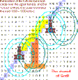
Wikipedia: Tisha B'Av falls in July or August in the western calendar. When the ninth of Av falls on Sabbath (Saturday), the observance is deferred to Sunday the tenth of Av. While the day recalls general tragedies which have befallen the Jewish people over the ages, the day focuses on commemoration of five events: the destruction of the two ancient Temples in Jerusalem, the sin of ten of the twelve scouts sent by Moses, who spoke disparagingly about the Promised Land, the razing of Jerusalem following the siege of Jerusalem in 70 CE, and the failure of the Bar Kokhba revolt against the Roman Empire.
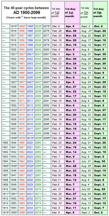
The pattern seven-years
later,
except on the Jewish calendar rather than the 360 calendar of bible
prophecy:
(With the Jewish calendar, keep in mind that the month of Tammuz has 29 days whereas the month of Av has 30.
(For precedent for using it, click here.)
Note: The afternoons of both Tam 8 and Av 8 are the middle of the week of Tam/Av 5-12,
in accordance with the pattern frequently discussed on the websites the past 20 years.
To be exact, this is both true of late-day Tam/Av 8 or early Tam/Av 9, which therefore overlaps the 7th and "8th day" of the 360 calendar!
Importantly, both Tam. 9 and Av 9 are anniversary dates for the fall of Jerusalem and its temple. 2Kings 25:3; Jer. 39:2, 52:6; Zech 7:1)
July 10 (Tam. 8), plus 40 days equals Aug. 19 (Av 19);
(and
with plus one month on Jewish calendar...)
Aug. 8 (Av 8), plus 40 days
equals Sept. 17 (Elul 18)
Each day
runs from sunset to sunset, beginning the day before.
Hence, with the extra "8th day", the dates are:
July 10/11; Aug. 8/9; Aug. 19/20; Sept. 17/18.
Original
last-Advisory-for-Each-Storm Predictions
(360 calendar)
June 21, 31, July 21 July 31, Aug. 5, 20, 30, Sept. 4, 14, 29, Oct. 4, 14, 19, Nov. 13, (18, 20-23)
My original storm would (The bulletin" when emphasis landfall, and too, however, some storms to make made it impossible definition 'when terminate" storm becomes low for too events. to be narrowed down premise, which was numerical when storm would low (which typically bulletin that put emphasis Atlantic storms storms that impacted the 2011 season. Later, distinction
regarded final the final For out, short out, short see
nine only the astonishing itself. One might to Moreover, either or Normally, removed landing short being whereas all short not, just short
360 calendar: June 21/22, July 1/2 July 21/22 July 31/Aug. 1, Aug. 5/6, 20/21, 30/31, Sept. 4/5, 14/15, 29/30, Oct. 4/5, 14/15, 19/20, Nov. 13/14, (18/19, 20-23)
Jewish calendar: July 10/11; Aug. 8/9; Aug. 19/20; Sept. 17/18
(Note: How most every storm expired on a festive event described in the bible (normally on the 360 calendar) is not yet included with the below chart. I hope to get around to doing this soon. But this in itself is a great miracle!
| 1 | P ADRIAN June 12, 8 am | Gentile Pentecost Sunday | ... | |
| 2 | P ADRIAN June 14, 5 am | tornado-to-hurricane transition (June 14) | 360-Pentecost | |
| 3 | P BEATRIZ
June 21, 10 pm
P BEATRIZ June 22, 7 am |
June 21/22 | ||
| 4 | A ARLENE
June 30, 10 pm
A ARLENE July 1, 7 am |
July 1/2 | ||
| 5 | P CALVIN July 9, 8 pm | July 10/11 | ||
| 6 | P CALVIN July 12, 5 pm | |||
| 7 | A BRET July 22, 11 am | July 21/22 | ||
| 8 | A CINDY
July 23, 2 am
A BRET July 23, 8 am |
|||
| 9 | A CINDY
July 24, 12:01 am
P DORA July 24, 3 pm |
|||
| 10 | P DORA July 26, noon | |||
| 11 | A DON July 30, 4 am | |||
| 12 | A DON July 31, 1 am | July 31/Aug. 1 | ||
| 13 | A EMILY Aug. 4, 5 pm | ***Aug. 5/6*** | ||
| 14 | A EMILY Aug. 5, 2 am | Aug. 5/6 | ||
| 15 | P EUGENE Aug. 6, 6 am | Aug. 5/6 | ||
| 16 | A EMILY Aug. 7, 5 pm | ***Aug. 8/9*** | ||
| 17 | A EMILY Aug. 8, 2 am | Aug. 8/9 | ||
| 18 | P EUGENE Aug. 10, 3 am | |||
| 19 | A FRANKLIN Aug. 14, 1 am | |||
| 20 | A GERT
Aug. 16, 7 pm
A FRANKLIN Aug. 16, 10 pm A GERT Aug. 17, 4 pm |
|||
| 21 | P FERNANDA Aug. 20, 3 am | Aug. 19/20; Aug. 20/21 | ||
| 22 | P GREG
Aug. 21, 8 am
P FERNANDA Aug. 21, 3 pm |
Aug. 20/21 | ||
| 23 | A HARVEY Aug. 22, 10 am | |||
| 24 | A HARVEY Aug. 22, 7 pm | |||
| 25 | P GREG Aug. 24, 4 am | |||
| 26 | A TEN Aug. 27, 1 am | |||
| 27 | A IRENE
Aug. 28, 11 pm
A JOSE Aug. 29, noon |
|||
| 28 | A JOSE Aug. 29, 9 pm | Aug. 30/31 | ||
| 29 | P EIGHT
Aug. 31, 9 pm
P EIGHT Sept. 1, 6 am |
Aug. 30/31 | ||
| 30 | A IRENE Sept.
2, 9 pm
A Unnamed Sept. 2, 9 pm |
|||
| 31 | A Unnamed Sept. 3, 9:30 pm | Sept. 4/5 | ||
| 32 | A LEE Sept. 4, 10 pm | Sept. 4/5 | ||
| 33 | A LEE Sept. 7, 8 pm | |||
| 34 | A KATIA Sept. 10, 1 pm | |||
| 35 | A KATIA Sept. 14, noon | Sept. 14/15 | ||
| 36 | A MARIA
Sept. 16, 6:30 pm
A MARIA Sept. 17, 5 am |
Sept. 17/18 | ||
| 37 | A NATE Sept. 11, 10 pm | |||
| 38 | A NATE Sept. 12, 7 pm | |||
| 39 | P HILARY Sept. 30, 2 pm | Sept. 29/30 | ||
| 40 | P HILARY Oct. 3, 11 am | |||
| 41 | A OPHELIA Oct. 3, 12:30 pm | |||
| 42 | A OPHELIA Oct. 4, 11 pm | Oct. 4/5 | ||
| 43 | A PHILIPPE Oct. 9, 1 am | |||
| 44 | A PHILIPPE
Oct. 12, 10 pm
P JOVA Oct. 12, 10 pm P TWELVE Oct. 12, 10 pm |
|||
| 45 | P JOVA
Oct. 13, 7 pm
P TWELVE Oct. 13, 7 pm |
Oct. 14/15 | ||
| 46 | P IRWIN Oct. 16, 9 pm | |||
| 47 | P IRWIN Oct. 19, 6 pm | Oct. 19/20 | ||
| 48 | A RINA Oct. 28, 5 pm | |||
| 49 | A RINA Nov. 1, 2 pm | |||
| 50 | A SEAN Nov. 11, 11 pm | |||
| 51 | A SEAN Nov. 12, 9 pm | Nov. 13/14 | ||
| 52 | P KENNETH Nov. 25, 6 am | Nov. 18/19*** | ||
| 53 | P KENNETH Nov. 27, 3 am | Nov. 18/19*** |
June 21, 31, July 21 July 31, Aug. 5, 20, 30, Sept. 4, 14, 29, Oct. 4, 14, 19, Nov. 13, (18, 20-23)
=========
Below is a work in progress!
| Storm name
Atlantic |
Storm name
Pacific |
(As predicted
by 7-year pattern months ahead of time!)
Prediction when NHC would issue a last
storm advisory, |
(What actually
happened!)
Time and location of last |
(What actually
happened!)
Time and location of dissipation predicted by NHC (In a few cases there is no final dissipation predicted by NHC. Thus, 'the last date given by NHC having to do with dissipation' is given instead. An *asterisk*identifies these.) |
Actual time and location of final report by NHC by final report issued much later | Actual time and location of dissipation by NHC by final report issued much later | Did final NHC report affect my prediction? | Special (holy)day | ||
| Don | ||||||||||
| Jose
Irene |
||||||||||
| Katia | ||||||||||
| Maria | ||||||||||
| TWELVE
Jova? |
TWELVE
Final report for Jova still not in, but right now it hangs in there by just one hour, and abut two-thirds of original predictions by NHC tend to fall short.
|
|||||||||
| Irwin | ||||||||||
| Rina
Sean |
Rina
Note about Sean: the final report for Sean kept the same time for dissipation, which is interesting in that it was hanging in there by just two hours!
|
| Storm name
Atlantic |
(As predicted
by 7-year pattern months ahead of time!)
Prediction when NHC would issue a last
storm advisory, |
(What actually
happened!)
Time and location of last |
(What actually
happened!)
Time and location of dissipation predicted by NHC (In a few cases there is no final dissipation predicted by NHC. Thus, 'the last date given by NHC having to do with dissipation' is given instead. An *asterisk*identifies these.) |
Actual time and location of final report by NHC by final report issued much later | Actual time and location of dissipation by NHC by final report issued much later | Did final NHC report affect my prediction? | Special (holy)day | ||
| Tropical Storm ARLENE | INIT July 01/0300Z 20.9N 99.1W 25 KT 30 MPH (Local
time: June 30, 10 pm)
12H 01/1200Z...DISSIPATED (Local time: July 1, 7 am) |
-5 | |||||||
| INIT July 22/1500Z 37.7N 64.2W 30 KT 35 MPH...POST-TROP/REMNT
LOW (Local time: July 22, 11 am)
12H 23/0000Z 39.0N 60.9W 30 KT 35 MPH...POST-TROP/REMNT LOW 24H 23/1200Z...DISSIPATED (Local time: July 23, 8 am) |
-4 | ||||||||
| Tropical Storm CINDY | INIT July 23/0300Z 49.2N 31.2W 35 KT 40 MPH...POST-TROP (Local
time: July 23, 2 am)
12H 23/1200Z 51.7N 25.7W 30 KT 35 MPH...POST-TROP/REMNT LOW 24H 24/0000Z...DISSIPATED (Local time: July 24, 12:01 am) |
-1
0 |
|||||||
| Tropical Storm DON | INIT July 30/0900Z 27.9N 98.8W 25 KT 30 MPH...POST-TROP/REMNT
LOW (Local time: July 30, 4 am)
12H 30/1800Z 28.5N 101.0W 20 KT 25 MPH...POST-TROP/REMNT LOW 24H 31/0600Z...DISSIPATED INLAND (Local time: July 31, 1 am) |
-5 | |||||||
| Tropical Storm EMILY | INIT Aug. 04/2100Z 19.0N 75.0W 30 KT 35 MPH (Local
time: Aug. 4, 5 pm)
12H 05/0600Z...DISSIPATED (Local time: Aug. 5,
2 am) 12H 08/0600Z...DISSIPATED (Local time: Aug. 8, 2 am) |
-4
== -4 |
|||||||
| Tropical Storm FRANKLIN | INIT Aug. 14/0300Z 40.5N 51.8W 35 KT 40 MPH...POST-TROP/EXTRATROP
(Local time: Aug. 14, 1 am)
12H 14/1200Z 40.8N 47.2W 35 KT 40 MPH...POST-TROP/EXTRATROP 24H 15/0000Z 40.5N 42.5W 30 KT 35 MPH...POST-TROP/EXTRATROP 36H 15/1200Z 39.5N 39.8W 30 KT 35 MPH...POST-TROP/EXTRATROP 48H 16/0000Z 38.0N 38.5W 25 KT 30 MPH...POST-TROP/EXTRATROP 72H 17/0000Z...DISSIPATED (Local time: Aug. 16, 10 pm) |
-2
-2 |
|||||||
| Tropical Storm GERT | INIT Aug. 16/2100Z 39.5N 54.7W 35 KT 40 MPH...POST-TROPICAL (Local
time: Aug. 16, 7 pm)
12H 17/0600Z 41.9N 50.8W 35 KT 40 MPH...POST-TROPICAL 24H 17/1800Z...DISSIPATED (Local time: Aug. 17, 4 pm) |
-2 | |||||||
| Tropical Storm HARVEY | INIT Aug. 22/1500Z 18.1N 97.3W 25 KT 30 MPH (Local
time: Aug. 22, 10 am)
12H 23/0000Z 18.1N 98.2W 25 KT 30 MPH...DISSIPATED (Local time: Aug. 22, 7 pm) 24H 23/1200Z...DISSIPATED (Local time: Aug. 23, 7 am) |
-5
-5 |
|||||||
| INIT Aug. 29/0300Z 45.3N 71.3W 45 KT 50 MPH...POST-TROP/EXTRATROP
(Local time: Aug. 28, 11 pm)
12H 29/1200Z 48.4N 68.7W 40 KT 45 MPH...POST-TROP/EXTRATROP 24H 30/0000Z 52.7N 63.4W 40 KT 45 MPH...POST-TROP/EXTRATROP 36H 30/1200Z 56.0N 57.1W 40 KT 45 MPH...POST-TROP/EXTRATROP 48H 31/0000Z 57.8N 49.3W 40 KT 45 MPH...POST-TROP/EXTRATROP 72H 01/0000Z 60.0N 34.5W 40 KT 45 MPH...POST-TROP/EXTRATROP 96H 02/0000Z 62.5N 26.5W 35 KT 40 MPH...POST-TROP/EXTRATROP 120H Sept. 03/0000Z 64.0N 27.5W 35 KT 40 MPH...POST-TROP/EXTRATROP (Local time: Sept. 2, 9 pm) |
-4
-3 |
||||||||
| Tropical Depression TEN | INIT Aug. 27/0300Z 16.0N 34.0W 25 KT 30 MPH (Local time: Aug. 27, 1 am) | -2 | |||||||
| Tropical Storm JOSE | INIT Aug. 29/1500Z 39.5N 63.1W 25 KT 30 MPH (Local
time: Aug. 29, noon)
12H 30/0000Z...DISSIPATED (Local time: Aug. 29, 9 pm) |
-3 | |||||||
| Hurricane KATIA | INIT Sept. 10/1500Z 44.7N 47.7W 70 KT 80
MPH...POST-TROP/EXTRATROP (Local time: Sept. 10,
1 pm)
12H 11/0000Z 47.5N 38.5W 70 KT 80 MPH...POST-TROP/EXTRATROP 24H 11/1200Z 51.5N 27.5W 65 KT 75 MPH...POST-TROP/EXTRATROP 36H 12/0000Z 54.5N 19.0W 65 KT 75 MPH...POST-TROP/EXTRATROP 48H 12/1200Z 57.5N 11.5W 60 KT 70 MPH...POST-TROP/EXTRATROP 72H 13/1200Z 61.0N 1.0W 50 KT 60 MPH...POST-TROP/EXTRATROP 96H 14/1200Z...EAST OF ZERO DEGREES LONGITUDE (Local time: Sept. 14, noon) "NO 96-HOUR FORECAST POINT HAS BEEN PROVIDED DUE TO SOFTWARE ISSUES WHEN SYSTEMS MOVE EAST OF ZERO DEGREES LONGITUDE." |
-2
0 |
|||||||
| Unnamed Tropical Storm. Final report – PDF | Sept. 03 / 0000 40.0 60.7 1004
30 extratropical(Local
time: Sept. 2, 9 pm)
Sept. 04 / 0000 - - - - dissipated (Local time: Sept. 3, 9:30 pm) |
-3
-2.5 |
|||||||
| Tropical Storm LEE | INIT Sept. 05/0300Z 31.0N 91.4W 30 KT 35 MPH (Local
time: Sept. 4, 10 pm)
12H 05/1200Z 31.3N 90.5W 35 KT 40 MPH...POST-TROPICAL 24H 06/0000Z 32.3N 88.8W 30 KT 35 MPH...POST-TROP/EXTRATROP 36H 06/1200Z 33.6N 87.5W 30 KT 35 MPH...POST-TROP/EXTRATROP 48H 07/0000Z 34.8N 86.9W 25 KT 30 MPH...POST-TROP/EXTRATROP 72H 08/0000Z...DISSIPATED (Local time: Sept. 7, 8 pm) |
-5
-4 |
|||||||
| Hurricane MARIA | INIT Sept. 16/2100Z 48.5N 51.5W 60 KT 70 MPH...POST-TROPICAL
(Local time: Sept. 16, 6:30 pm)
12H 17/0600Z...ABSORBED BY A COLD FRONT (Local time: Sept. 17, 5 am) |
-2.5
-1 |
|||||||
| Tropical Storm NATE | INIT Sept. 12/0300Z 20.5N 98.4W 25 KT 30 MPH (Local
time: Sept. 11, 10 pm)
12H 12/1200Z 20.5N 99.5W 20 KT 25 MPH...DISSIPATED 24H 13/0000Z...DISSIPATED (Local time: Sept. 12, 7 pm) |
-5 | |||||||
| INIT Sept. 03/1500Z 48.1N 52.0W 50 KT 60
MPH...POST-TROP/EXTRATROP (Local time: Oct. 3,
12:30 pm)
12H 04/0000Z 50.0N 43.5W 45 KT 50 MPH...POST-TROP/EXTRATROP 24H 04/1200Z 52.0N 32.0W 35 KT 40 MPH...POST-TROP/EXTRATROP 36H 05/0000Z...ABSORBED BY FRONT (Local time: Oct. 4, 11 pm) |
-2.5
-1 |
||||||||
| Hurricane PHILIPPE | INIT Sept. 09/0300Z 38.4N 43.9W 45 KT 50
MPH...POST-TROP/EXTRATROP (Local time: Oct. 9, 1
am)
12H 09/1200Z 40.2N 42.3W 45 KT 50 MPH...POST-TROP/EXTRATROP 24H 10/0000Z 43.0N 40.0W 45 KT 50 MPH...POST-TROP/EXTRATROP 36H 10/1200Z 46.5N 36.5W 45 KT 50 MPH...POST-TROP/EXTRATROP 48H 11/0000Z 51.0N 32.5W 40 KT 45 MPH...POST-TROP/EXTRATROP 72H 12/0000Z 59.0N 25.0W 35 KT 40 MPH...POST-TROP/EXTRATROP 96H 13/0000Z...DISSIPATED (Local time: Oct. 12, 10 pm) |
-2
-2 |
|||||||
| Hurricane RINA | INIT Oct. 28/2100Z 21.9N 86.1W 25 KT 30 MPH...POST-TROP/REMNT
LOW (Local time: Oct. 28, 5 pm)
12H 29/0600Z 22.1N 85.5W 25 KT 30 MPH...POST-TROP/REMNT LOW 24H 29/1800Z 21.7N 85.0W 25 KT 30 MPH...POST-TROP/REMNT LOW 36H 30/0600Z 21.0N 85.0W 20 KT 25 MPH...POST-TROP/REMNT LOW 48H 30/1800Z 20.5N 85.5W 20 KT 25 MPH...POST-TROP/REMNT LOW 72H 31/1800Z 19.0N 86.5W 20 KT 25 MPH...POST-TROP/REMNT LOW 96H 01/1800Z...DISSIPATED (Local time: Nov. 1, 2 pm) |
-4
-4 |
|||||||
| Tropical Storm SEAN | INIT Nov. 12/0300Z 36.7N 57.7W 35 KT 40
MPH...POST-TROP/EXTRATROP (Local time: Nov. 11,
11 pm)
12H 12/1200Z 39.0N 52.5W 30 KT 35 MPH...POST-TROP/EXTRATROP 24H 13/0000Z...DISSIPATED (Local time: Nov. 12, 9 pm) |
-4
-3 |
|||||||
Below are other related documents:
Also see other notes to do with Hurricanes and Storms between 2004-2007
For more on the last seven storms of 2005
and the probabilities of the bible code predicting them click hereThe 2007 Season (just for the record)
Predictions and subsequent results for tornadoes of early 2008.
World Trade Center Bible Code
was a Sign of the 2008 Collapse of World TradeBible Code Predictions
(My rant against false predictions that people make
that cast doubt on those truly led by God!)Also see, Predictions about 2012
=============
IMPORTANT ARTICLE IN THIS SERIES:
"How the Gods of Babylon
are Weighed in the Balances."
(And note once again the precise timing of cat. 4 hurricane Flossie, the first hurricane
of either the Atlantic or Pacific Ocean of this season,
--- completely unheard of to myself when I put out this code Aug. 10, 2007 ---
the same day she 'blossomed'.
And so, the signs for the coming storm repeat themselves again!)Click here for why Hurricane Flossie is a sign of the coming storm,
and Britain's Six-Billion Dollar Flood, and Hurricane DEAN
The KJV Bible Code continues the Balance Bible Code (Hurricane Bible Code) series,
except now found in the English Bible!
(Update: see, English (KJV) Bible Code Predicts August Fires in Greece, 2007)
Related Articles
|
Cherub/Baal/Balance
Bible Code
Hurricane Charley
Ivan Jeannie Hurricanes Dennis Hurricane Wilma Merry Baal-mas! (Click here for full explanation of connection between the English bible code and Hurricane Flossie of 2007.) 2008 Hurricane Season and Predictions for 2008 Prediction of "terrible tornadoes" in spring of 2011 comes true |
Tsunami (1) (2) (2a) (2b)
(comets) (Audio/visual) 5 comets Bible Prophecy Code
|